
A light snowfall befell Magnolia Tuesday morning as the calendar has yet to hit the midpoint of November. The small flurry, though, did not appear to adhere to any roadways and only lasted approximately 2-3 hours.
The earliest report of snow to the Banner-News indicated the small flurry began around 6:30 a.m. The flakes largely subsided by early-mid morning. Downtown Magnolia saw the snowfall stop just before 9 a.m. The square saw light snow, but some areas just north of the city near McNeil were seen with slightly larger snowflakes. A report from Camden indicated no snow was seen in the Ouachita County seat.
A Shreveport National Weather Service (NWS) social media post from Nevada County showed a slight accumulation of snow in Prescott, near I-30. The roadways, though, appeared to be clear. The wintry weather was seen at least as far south as Caddo Parish, Louisiana.
A 2:45 p.m. NWS report Tuesday indicated Tyler, Texas, was still receiving light snow.
Although the flurries seen locally Tuesday did not last long, the wintry weather did appear again Wednesday in the a.m. hours. The incident caused the National Weather Service of Shreveport to issue a winter storm warning until noon.
“Strong cold air advection will continue to penetrate deep East Texas into all of northern Louisiana [and southwest and south central Arkansas] such that freezing temperatures will be possible across these areas late tonight through mid-morning on Wednesday,” a Shreveport NWS hazardous weather outlook said.
The chances of snow Wednesday were pegged at only 20 percent. The weather report also stated the snow and sleet mix could net up to 1 inch and cause slippery roads and sidewalks.
The high in Magnolia observed Tuesday was 41 degrees. The overnight lows forecast for the area were 27 degrees, causing NWS to also issue a freeze warning through 9 a.m. Wednesday.
The region was not the only area in Arkansas that saw an early snowfall this week. The Arkansas Democrat-Gazette this week reported that Fayetteville and the Ozark Mountain area on Monday received up to 1 inch of snow, but, just like its southern Arkansas counterpart, the flakes did not stick. The soil temperature Monday was stated to be 50 degrees in the northwest portion of the state.
The regional winter storm developed from the remnants of a record-setting snowfall over the weekend in the Texas panhandle that dumped 7 inches of snow in some areas of the Lone Star State and dropped 1.6 inches of snow in Tulsa, the ADG report said.
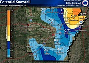
The Little Rock National Weather Service office stated the snow is now moving through the northern portion of the state. The storm was caused, the weather service said, due to an abundance of Gulf moisture that settled over the area, making conditions perfect for precipitation.
The heaviest expected snowfall is east of Mountain Home, where up to 3 inches could fall northeast of Jonesboro. Arkansas Online Tuesday reported the precipitation will begin as rain, then turn to snow as the system moves the region’s below freezing night.
In Magnolia, the Shreveport National Weather Service says the cold daytime temperatures won’t subside until Friday.
Wednesday night is expected to see lows of 26 degrees, with Thursday’s high of 50. Thursday night, according to early NWS reports, will again hit below freezing, with a low of 31 degrees. Friday, forecasters predict, will be a sunny, 61-degree day, with a nightly low of 38.
The weekend calls for similar temperatures. Rain chances may again creep into the area by next week.
Saturday’s skies are expected to be clear, with a high of 63 degrees and a low around 40, while a 20 percent chance of rain is forecast Sunday. The high that day is stated by the weather service to be 55 degrees, while the low is expected around 37.
A preliminary Thanksgiving Day forecast shows a 50 percent chance of showers with a high of 58 degrees and a low of 46. The forecast though is early and can easily change.